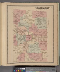
I came across this Historical Map of Chateaugay, NY from an 1876 Atlas of Franklin County, NY It’s got a lot of incredible information in it, largely because it shows the names of businesses and property owners. In District 13 at the top of the page, you can see the name “P. Bradshaw” right underneath the 13. There’s a fair amount to unpack here.
First – how cool is it that our farm was in District 13? Sounds sort of post-apocalyptic.
Second – This map was published in 1876, so it proves that we were living on the family farm as early as 1876. Also there are two dots associated with P. Bradshaw, one near the schoolhouse (SH) on the corner, and one farther East. The dots appear to be buildings or dwellings. The dot near the schoolhouse is definitely the main farm. The dot on the right (East) is right where “The Other Place” was. The building(s) are north of the brook, which puts them right about where dad showed me a low spot in on of the pastures that he thought was a cellar hole.
So – I guess it’s time to rent some ground-penetrating radar equipment and look for the old homestead.
Third – South of “P. Bradshaw” but still in District 13 is “R. Bradshaw”. That would have been Richard Bradshaw, Pat’s brother. There is an anecdote that Pat and Richard’s families would get together every Sunday, and Pat and Richard would go up the hay loft in the barn and polish off an imperial quart of Canadian Whiskey. I can still hear Uncle John telling me that one.
Anyways, this map has enough info for lots more posts.
Stay tuned.


